
Geological Survey of Finland team: Peter Sorjonen-Ward, Ville Järvinen, Mahyra Tedeschi, and Mikael Vasilopoulos
Latitude 66 Cobalt Oy team: Otso Markkanen and Teemu Kaikuranta
The Kuusamo Belt: the place of an unusual reunion of economic elements
Last summer, a team from the Geological Survey of Finland (GTK) travelled to northeastern Finland to investigate the rocks of the Kuusamo Belt (Fig. 1). This region was shaped between 2.44 and 1.8 billion years ago, during a long period of geological activity that included sedimentation in seas, volcanic eruptions, mountain building, and the circulation of hot fluids deep underground.
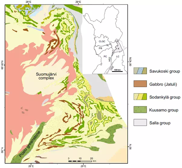
Fig. 1 Geological map of the Kuusamo belt. Legend on right illustrates the stratigraphic order of the Kuusamo Belt rock sequences from oldest (bottom) to youngest (top). Inset in upper-right corner shows location of Kuusamo Belt (K) in northeastern Finland. (Figure from: Nironen M., 2017, Geological Survey of Finland, Report of Investigation 234).
These ancient processes enriched some of the rocks in the area with metals. Early explorers searched for gold, and later studies by the GTK also identified cobalt and rare earth elements. This particular combination of metals occurring together, however, is unusual. It suggests that there were several different metal-enriching events that took place here a long time ago, with the younger events overprinting the older events. Understanding where these metals came from, and how they were transported and enriched in the ancient earth of the Kuusamo belt over 2 billion years ago, is essential for evaluating the mineral potential of the Kuusamo Belt today.
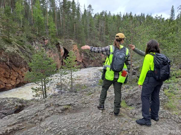
Fig. 2 GTK’s team discussing the tectonic structures at the outcrop in Oulanka, Kuusamo. The present-day bedrock is a schist, but it was produced by high-temperature and pressure recrystallization of sand and silt particles, which were originally deposited in a shallow lagoon or sea. Photograph by Mikael Vasilopoulos.
What history can rocks tell us?
In UNDERCOVER, we use the mineral systems approach, which focuses on understanding the geological processes that form certain types of mineral deposits in general, rather than just the individual deposits themselves. Fieldwork is a key part of this approach. By visiting rock outcrops (places where rocks are naturally exposed on the surface) we can collect clues about the environments and events that shaped the region (Fig. 2).
During the field campaign, we asked questions such as:
- What kind of environment existed here when these rocks formed : a shallow sea, a river delta, or a volcanic landscape?
- Was free oxygen present in the water or atmosphere at that time?
- Were the fluids that moved through the rocks salty, hot, or chemically reactive?
- How could these fluids have transported metals like gold and cobalt?
- Where and why would these fluids precipitate and concentrate the metals they carried?
- And when did all of this happen? Were the surrounding rocks cool and brittle or hot and ductile at the time?
To answer these questions, we visited outcrops along roads, cliffs, and former mining areas, including sites operated by the company Latitude 66 Cobalt Oy. We mapped fractures, folds, and other structures in the rocks that can act as “pathways” for transporting mineral‑rich fluids. These kinds of structures often repeat at different scales, much like fractals, linking small‑scale observations to regional patterns.
We also examined the minerals present in each rock and the relationships between them. This helps us reconstruct the sequence of geological events — which minerals formed first, which came later, and under what conditions (Fig. 3). Selected samples were taken for thin‑section microscopy to study the relationships between various stages of mineral growth and deformation, and for isotopic age dating, which will allow us to place key events in chronological order.
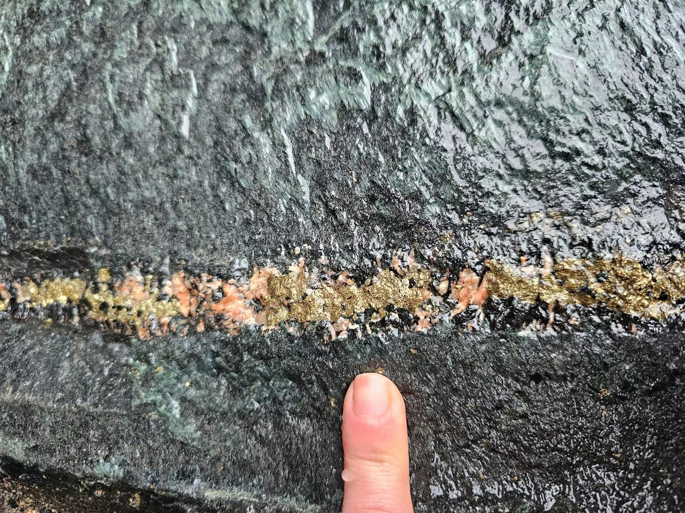
Fig. 3 Mineralization of yellowish sulfide-minerals (iron-rich pyrite and copper-bearing chalcopyrite) along with some pink and black silicate minerals hosted in a narrow coarse-grained vein. The vein is a planar structure that cuts the dark-colored primary rock, indicating that the vein is younger compared to the formation of the dark rock. The vein was formed after the formation of the dark rock by high-pressure injection of metal-bearing hot fluids originating from an unknown source.
Connecting the rocks above and underneath the surface: UNDERCOVER
The rocks we see at the surface are only part of the story. UNDERCOVER aims to connect surface observations with what lies beneath, using geophysical data and drill cores where available. Geophysical methods allow us to “see” into the subsurface, revealing structures and rock types that are not exposed.
By combining field observations, laboratory analyses, and geophysical imaging, we can build a much clearer picture of how metals formed in the Kuusamo Belt and where they might still be hidden today — even in areas covered by soil, vegetation, or younger rocks.
The samples collected during the fieldwork are now being studied in the laboratory. We are examining minerals under the microscope, analyzing the chemical composition of the rocks, and determining the age of key minerals. These results will be integrated with geophysical interpretations to create a detailed mineral systems model for the Kuusamo Belt.